 |
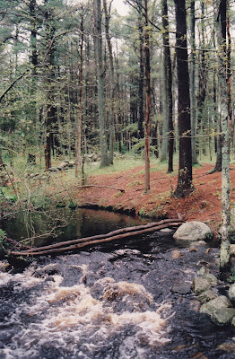
| Second Herring Brook at the Norris Reservation in Norwell. |
I probably would not have gone for a walk last Tuesday afternoon if I hadn’t remembered that Daylight Savings Time was due to begin. I’ve grown accustomed to taking a walk in the woods, along the river, or on the beach after work but now that the days are growing shorter, it will be all but dark when I leave the office at 5 PM. Walks will become morning and weekend events, as the return of Daylight Savings Time brings me back to my winter schedule.
This week’s walk took me to the Norris Reservation off Route 123 in Norwell. Managed by the Trustees of Reservations, this property is usually quite crowded at the end of the day, but with the rainy weather, the trails were practically deserted.
For those who may have forgotten, last weekend was the wet one. At least one Norwell resident measured six inches of rain on his backyard meter, and reports of local flooding were all over the news. Aside from some really big puddles however, I had yet to see any evidence of this influx of water. Driving over the North River around low tide on Monday afternoon, I noted that the river really didn’t look much different than usual.
My understanding of watershed mechanics changed as I walked down the path into the Norris Reservation. Through this 117-acre parcel flows Second Herring Brook, which drains Black Pond and a wide section of the eastern part of Norwell. Just below the mill pond on the property is a bridge, and below this bridge there is usually a quiet stream bubbling over the rocks, gently winding its way through the woods and emptying into the North River.
Last Tuesday it was different. I could hear the roar of the water as soon as I stepped down the path. Reaching the pond I was startled to see that both the pond and the brook had overflowed their banks, and that the quiet stream had turned into a raging torrent. A picnic table placed on a slight rise which usually affords a nice view of the brook was surrounded by swirling water. There was evidence that the flooding had been much worse the day before, as channels had been cut in the forest floor as the pond water attempted to escape its boundaries.
Thus my lesson in watershed mechanics. When it rains like crazy for three days straight, what happens to all that water? Some of it is absorbed into the ground, sometimes immediately, other times it stands in puddles for a while before slowly sinking in. But most of it flows over land. Downhill, into the wetlands, creeks, and little brooks that feed larger brooks, and from there into rivers like the North and South. The rivers flow to the ocean.
In the larger bodies of water we might not notice as dramatic a change as in the smaller ones — a gallon of water poured into the Atlantic is far less noticeable than the same gallon poured on your basement floor — but the change still occurs. The water has to go somewhere. While I could not detect much of a change in the North River estuary along Route 3A in Scituate, the difference in Second Herring Brook, one of its tributaries, was plain to see.
Driving home later that day I paid much more attention to the little brooks and streams that pass, unannounced, under our roads and highways. All of them were swollen, overflowing their banks and leaving big puddles in their wake. As I reached the South River in Marshfield Center I could hear the water raging in the distance. Looking upstream, I saw a most unusual sight. Veterans Memorial Park was under water! Furnace Brook and the upper reaches of the river were so full of water that they had flooded the park.
The area drained by a river or river system is known as a watershed. Basically, any rain that falls within the boundaries of a watershed stays within that watershed until it flows to sea. Portions of the towns of Abington, Duxbury, Hanover, Hanson, Hingham, Marshfield, Norwell, Pembroke, Rockland, Scituate, Weymouth, and Whitman drain into the North and South Rivers. While most of this drainage occurs in subtle ways, we really notice it when there’s a heavy rainfall.
by Kezia Bacon
November 1996
Kezia Bacon is the Assistant Director of the North and South Rivers Watershed Association (NSRWA).
